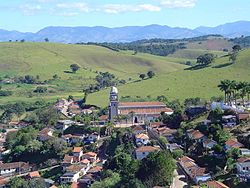
Pouso Alto
Tools
Actions
General
Print/export
In other projects
From Wikipedia, the free encyclopedia
The printable version is no longer supported and may have rendering errors. Please update your browser bookmarks and please use the default browser print function instead.
Municipality in Southeast, Brazil
Pouso Alto | |
|---|---|
Municipality | |
 | |
| Coordinates: 22°11′37″S 44°58′21″W / 22.19361°S 44.97250°W / -22.19361; -44.97250 | |
| Country | |
| Region | Southeast |
| State | Minas Gerais |
| Mesoregion | Sul/Sudoeste de Minas |
| Elevation | 884 m (2,900 ft) |
| Population (2020 [1]) | |
| • Total | 5,900 |
| Time zone | UTC−3 (BRT) |
Pouso Alto (translation: High Landing) is a municipality in the state of Minas Gerais in the Southeast region of Brazil.[2][3][4][5]
The municipality contains 4.39% of the 22,917 hectares (56,630 acres) Serra do Papagaio State Park, created in 1998.[6]
See also
References
- ^ IBGE 2020
- ^ "Divisão Territorial do Brasil" (in Portuguese). Divisão Territorial do Brasil e Limites Territoriais, Instituto Brasileiro de Geografia e Estatística (IBGE). July 1, 2008. Retrieved December 17, 2009.
- ^ "Estimativas da população para 1º de julho de 2009" (PDF) (in Portuguese). Estimativas de População, Instituto Brasileiro de Geografia e Estatística (IBGE). August 14, 2009. Retrieved December 17, 2009.
- ^ "Ranking decrescente do IDH-M dos municípios do Brasil" (in Portuguese). Atlas do Desenvolvimento Humano, Programa das Nações Unidas para o Desenvolvimento (PNUD). 2000. Archived from the original on October 3, 2009. Retrieved December 17, 2009.
- ^ "Produto Interno Bruto dos Municípios 2002-2005" (PDF) (in Portuguese). Instituto Brasileiro de Geografia e Estatística (IBGE). December 19, 2007. Retrieved December 17, 2009.
- ^ PES da Serra do Papagaio (in Portuguese), ISA: Instituto Socioambiental, retrieved 2016-09-27
22°11′38″S 44°58′22″W / 22.1939°S 44.9728°W / -22.1939; -44.9728
This geographical article relating to Minas Gerais is a stub. You can help Wikipedia by expanding it. |


