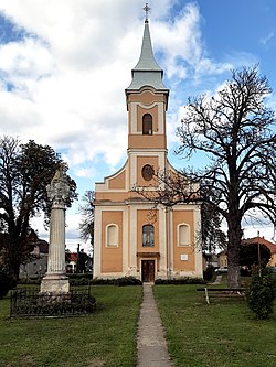
Királyegyháza
You can help expand this article with text translated from the corresponding article in Hungarian. (January 2011) Click [show] for important translation instructions.
|
Királyegyháza | |
|---|---|
Village | |
 Roman Catholic Church | |
| Coordinates: 46°00′N 17°58′E / 46.000°N 17.967°E | |
| Country | |
| County | Baranya |
| Time zone | UTC+1 (CET) |
| • Summer (DST) | UTC+2 (CEST) |
Királyegyháza is a village in Baranya county, Hungary.
Demographics[edit]
In 2023, the town had a total population of 814. As of the 2022 census, the town was 91.5% Hungarian, and 2.7% Gypsy. The population was 35.6% Roman Catholic, 3.1% Reformed, and 15.1% nondenominational.[1]
References[edit]
- ^ "Magyarország helységnévtára". www.ksh.hu. Retrieved 2024-06-10.


